


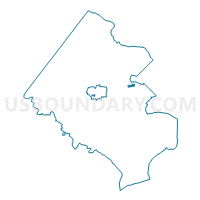
Graham Voting District, Fairfax County, Virginia
About
Outline

Summary
| Unique Area Identifier | 681538 |
| Name | Graham Voting District |
| County | Fairfax County |
| State | Virginia |
| Area (square miles) | 0.32 |
| Land Area (square miles) | 0.32 |
| Water Area (square miles) | 0.00 |
| % of Land Area | 100.00 |
| % of Water Area | 0.00 |
| Latitude of the Internal Point | 38.86789850 |
| Longtitude of the Internal Point | -77.19532850 |
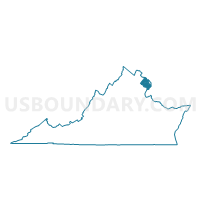
Maps

Graphs
Select a template below for downloading or customizing gragh for Graham Voting District, Fairfax County, Virginia


Neighbors
Neighoring Voting District (by Name) Neighboring Voting District on the Map
- Fort Buffalo Voting District, Fairfax County, VA
- Greenway Voting District, Fairfax County, VA
- Pine Spring Voting District, Fairfax County, VA
- Westlawn Voting District, Fairfax County, VA
- Whittier Voting District, Fairfax County, VA
Top 10 Neighboring County Subdivision (by Population) Neighboring County Subdivision on the Map
Top 10 Neighboring Place (by Population) Neighboring Place on the Map
Top 10 Neighboring Unified School District (by Population) Neighboring Unified School District on the Map
Top 10 Neighboring State Legislative District Lower Chamber (by Population) Neighboring State Legislative District Lower Chamber on the Map
Top 10 Neighboring State Legislative District Upper Chamber (by Population) Neighboring State Legislative District Upper Chamber on the Map
Top 10 Neighboring 111th Congressional District (by Population) Neighboring 111th Congressional District on the Map
Top 10 Neighboring Census Tract (by Population) Neighboring Census Tract on the Map
- Census Tract 4501, Fairfax County, VA (5,442)
- Census Tract 4503, Fairfax County, VA (4,806)
- Census Tract 4506.02, Fairfax County, VA (4,639)
- Census Tract 4502, Fairfax County, VA (4,608)
- Census Tract 4505, Fairfax County, VA (3,016)